Read and write
Enhanced in V10Read and write spatial data using a wide range of file formats and spatial servers
Spatial Manager Desktop™ allows you to read and write a broad spectrum of geospatial data from/to files (OpenStreetMap, KML/KMZ, Shapefiles, GML, etc.) and servers or data stores (PostGIS, SQL Server, WFS, etc.) (Data Providers list).
Use Spatial Manager Desktop™ advanced wizards to define source and target spatial data and import or export parameters.
Calculate geometric transformations of the features in the import and export processes
Spatial Manager Desktop™ will calculate geometric transformations of the features in the import and export processes, which will depend on the chosen Coordinate System (CRS) for the source and target data.
The user can choose the appropriate CRSs from a complete CRS catalog or from a list which includes the most recent used CRSs.
Background maps
Enhanced in V10Choose from among a lot of dynamic Backgrounds Maps from providers such as Google Maps, OpenStreetMap, Bing, MapBox, Ordnance Survey, etc., or configure your own maps from TMS, WMS or WMTS servers
Spatial Manager Desktop™ allows to the users choose from among a lot of dynamic Backgrounds Maps from many providers such as Google Maps, OpenStreetMap, Bing, MapBox, Ordnance Survey, etc., or customized maps from TMS, WMS or WMTS servers. These maps will enhance your documents quality and will let the users compare and check better.
The map images are automatically updated when the document view changes (zoom, pan, etc.) and the images resolution is automatically adapted to the view size. The user can export/import customized map definitions to be shared with other users.
Export all or part of the elements in the visible Layers of the map and their data to a KML or KMZ file
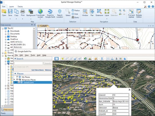
Spatial Manager Desktop™ includes a specific function designed to Export all or part of the objects in the visible Layers of the map and their data, to a KML or KMZ file (Google Earth) through a one-click operation.
The current Layers organization and the properties of the Layers and features are considered when creating the resulting GE file, and this file can be opened directly in Google Earth (if installed).
Arrange your maps in Layers that can be fully managed by the application
Spatial Manager Desktop™ allows you to structure your maps by Layers whose control is found in a multitude of functions designed to optimize your documents.
You will be able to organize your Layers in addition to those generated automatically in the import processes, sort them, control their visibility, etc. Spatial Manager Desktop™ also includes advanced functions to separate the information by Layers according to data values, export complete Layers or control selections or the map view according to the selected Layer.
Manage the alphanumeric data attached to the elements, design and edit the structure which will be used to store the data
Calculate simple or complex expressions using operators and functions that can be applied to field values in a table and/or to constant values
Calculation of new or existing field values using arithmetic, mathematical, date, etc., expressions. Include constant values and/or values from other fields.
Geometric functions like Area or Perimeter are also available.
Perform spatial analysis operations over the objects in the drawing or map generating new objects from such analysis
Spatial Manager Desktop™ provides a comprehensive set of tools to perform spatial analysis operations over the vector objects of the drawing or map and their attached data, resulting in new objects generated by the resolution of such operations.
Spatial analysis operations can be performed on a combination of tables, layers or drawing objects previously selected by interacting with on-screen elements or by using the application's advanced selection queries.
Location and geo-coding tools help to add reference elements and enhanced data to existing objects
Get locations from unreferenced addresses or add data to existing objects.
Built in Bing, Google and OpenStreetMap data providers offer wide range of data access.
Geometry tools
New in V10A set of tools to edit and transform polylines, polygons, and other spatial geometries
Create new shapes from existing elements, generate polygons from points, and simplify complex features.
Advanced functions like Convex Hull, Envelope, and Triangulation offer additional ways to restructure and analyze your data.
Spatial Manager Desktop™ includes the ability to save Tasks that make it easy to run repetitive import and export processes
Spatial Manager Desktop™ Tasks are the way the user can save any import or export process and its parameters in order to run repetitive processes for import or export data tables.
The user can execute any Task directly from the application or from the operating system command window; this feature also lets the user define powerful batch processes
Pay once, no periodic fees
Licenses are perpetual and never expire, with all purchases made as one-time payments—no subscriptions required. Each license includes one year of updates and support, with an optional discounted 3-year support plan available. Flexible use options with network licenses.


