Learn quickly and easily how to integrate Google Earth high quality images with your DWG using your preferred CAD platform. A wide range of resolutions are available up to 8K UHD, that will provide a full detailed aerial imagery and enrich your design workflow
Available for AutoCAD, BricsCAD, ZWCAD and GstarCAD
1. Locate your working area
- If you have a DWG already geolocated, execute SPMCREATEKML command, create a KML in one-step and open it with Google Earth
- For starting a new project go directly to step 2 and locate it in Google Earth searching your location
2. Set the desired layers and view in Google Earth
- Once the view is located, hide your project elements
- Then enable the layers you want to include and hide the others
3. Set top-north view
- Click on the map and press ‘R’ key or go to menu “View/Reset/Tilt and Compass”
4. Create .geprint auxiliar file
- Click on “Save image” icon or go to menu “File/Save/Save image”. You can also use the keyboard shortcut Ctrl+Alt+S
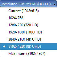
- Select your desired resolution, up to 8K UHD (do no select the “Maximum” option, because the variable image proportion will not be recognized and can not be imported)
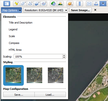
- Click on “Map Options” and hide the undesired elements: Title and Description, Legend, Scale, Compass…
- Above, on the section “Map Configuration”, click “Save…“, and save the .geprint configuration file.
5. Save image file
- Click “Save image…” and save the image next to the .geprint saved in the step 3. It is recommended to use the same file name, otherwise, the .geprint must be selected manually on the final step
6. Import using Spatial Manager
- Import the saved image using SPMIMPORT command or directly from the Spatial Manager palette (SPM command)
- If not selected automatically, check the “Google Earth print (.geprint)” option and select the .geprint file
7. Review the imported raster image
- Select the image and send to back (DRAWORDER command)
Notes:
- This method is compatible with Google Earth Pro on desktop, not Google Earth on web, neither Google Earth on mobile
- Some functionalities can be found in the Standard or Professional editions only


